Key facts
- Sentinel-6B completed calibration on Oct. 30 and will become the reference satellite in January for other sea-level missions to calibrate their data.
- NASA and its European partners launched Sentinel-6B on Nov. 16, 2025.
- Sentinel-6 Michael Freilich currently fills the reference satellite position.
- High-precision ocean measurements from the pair improve hurricane forecasts.
Calibration of Sentinel-6B finished on Oct. 30, NASA said, and the spacecraft will take over the reference role in January, so other sea-level missions can calibrate their data against it.
NASA said the spacecraft finished initial system checks, verifying that its data meets strict quality and accuracy standards. NASA completed those checks before the spacecraft assumes the reference role from its predecessor.
Sentinel-6 Michael Freilich currently occupies the reference satellite position, NASA says. The older spacecraft will stay in service until the handover occurs in January. The launch of Sentinel-6B by NASA and its European partners took place on Nov. 16, 2025. The spacecraft completed checkout in late 2026, NASA says.
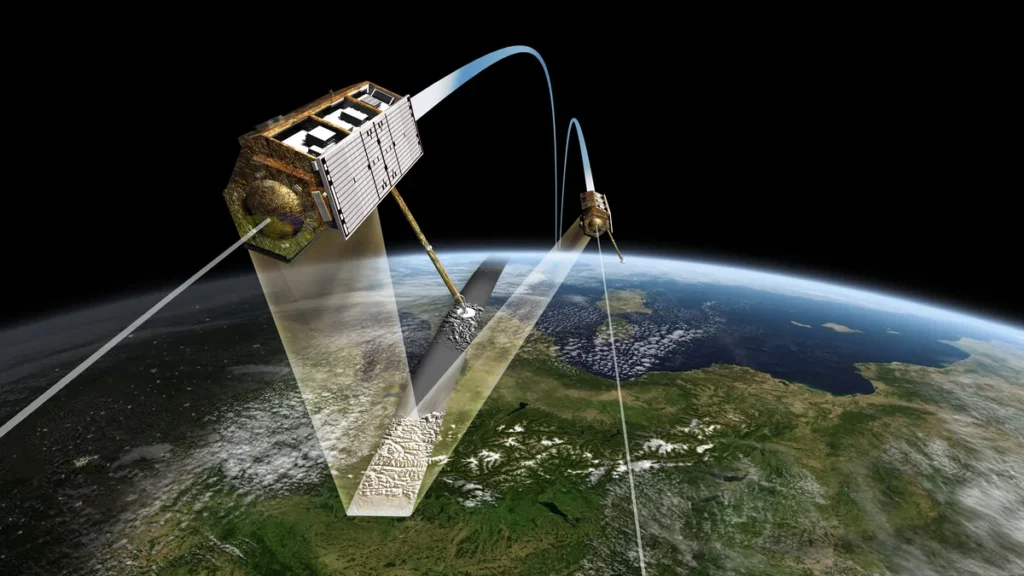
The two spacecraft form the Copernicus Sentinel-6/Jason-CS (Continuity of Service) mission, NASA says. The agency calls it the newest member of a long-running family in ocean altimetry. The mission represents the latest effort in a continuing series of radar altimetry projects that watch the ocean.
The series builds on decades of earlier ocean-observing missions, NASA says. The series has kept an unbroken watch over Earth‘s oceans along the same path dating back to the early 1990s. Keeping the same ground track maintains continuity across generations of spacecraft.
Sentinel-6 Michael Freilich leads Sentinel-6B by 30 seconds, NASA says. The separation will end when the older spacecraft shifts into an accompanying orbit beside its twin.
NASA says the maneuver will permit both spacecraft to fly together in formation. Flying together will let the pair deliver higher-resolution data than either spacecraft could manage alone. The agency calls the accompanying orbit the mechanism for gaining that improvement.
The Sentinel-6 satellites gauge ocean height along with wave size and marine wind speed, NASA says. The spacecraft collect these observations using a radar altimeter that beams signals toward the sea surface. Each spacecraft carries a radar altimeter, an active sensor, that fires thousands of radar pulses every second at wave crests and troughs.
NASA says ocean height comes from timing how long the returning echoes take to reach the spacecraft. The time for a radar pulse’s round trip shows how far the spacecraft sits above the ocean surface.
Because warm water expands, NASA says, sea level serves as an indicator of ocean volume and temperature. Scientists can use that relationship to infer ocean heat content and water volume from surface-height readings.
The spacecraft are supplying crucial data during an El Niño that oceanographers expect will be historic, NASA says. Oceanographers regard the ongoing event as a significant climate pattern that occurs naturally.
NASA says that during El Niño, unusually warm water spanning the central and eastern Pacific shifts weather patterns around the world. The phenomenon involves surface waters that run unusually warm in parts of the Pacific Ocean. Scientists plan to use the data to examine sea-level changes linked to the event.
Researchers also plan to track longer-term shifts in global ocean height with those same observations, NASA says. The observations will track long-term changes in global sea level. The result is a longer sea surface height record that scientists rely on to observe climate trends.
The pair’s high-precision ocean measurements improve hurricane forecasts, NASA says. Those same observations also aid infrastructure protection and commercial shipping operations. NASA counts infrastructure protection among the mission’s practical benefits, alongside forecasting and commerce. NASA names shipping as one of the commercial industries gaining from the ocean data.



Join the discussion