Key facts
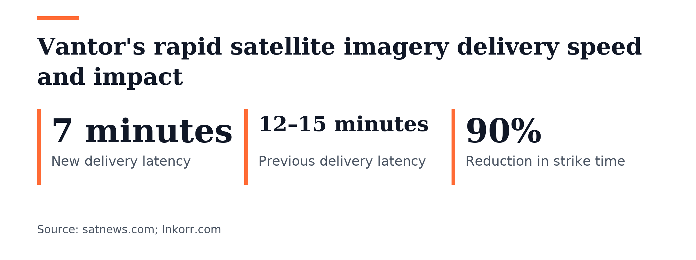
- Vantor demonstrated delivering satellite imagery to Ukrainian frontline forces in seven minutes of tasking during a late October 2026 field test.
- Vantor previously achieved satellite imagery delivery times of 12 to 15 minutes under optimal conditions before the seven-minute milestone.
- Conventional satellite imagery tasking, collection, processing, and delivery typically take several hours due to downlink schedules, cloud processing delays, and distributed command chains.
- Vantor reduced imagery delivery time to seven minutes by modernizing its ground segment and cloud distribution architecture, not by changing onboard spacecraft payloads.
Vantor delivered high-resolution satellite imagery to a soldier’s handheld tablet in Ukraine within seven minutes of tasking during a late October 2026 field test. The company called the result a new benchmark for space-based tactical intelligence dissemination. The company presented the direct tablet delivery as a new benchmark for sharing tactical intelligence from space. The announcement framed the event as an operational field test in Ukraine where forces on the front line received imagery within seven minutes of tasking.
Vantor had reached delivery times of 12 to 15 minutes in favorable conditions before the seven-minute milestone. The earlier benchmark predates the company’s recent optimizations to its ground segment and cloud distribution architecture. The improvement came from speeding up automated collection scheduling, regional downlink antenna links, and edge cloud processing. Modernization of the ground segment and cloud distribution architecture, rather than changes to spacecraft payloads, earned the credit for the improvement.
Vantor’s automated tasking-to-downlink pipeline checks collection requests and sends commands to approaching orbital passes, cutting processing delays. The company turns raw sensor data into actionable geographic overlays and sends compressed tactical files straight to field terminals, bypassing centralized command headquarters. Troops in the field with portable radios and tablets can query passing spacecraft and get near real-time overhead intelligence without centralized headquarters. The automation is part of the company’s effort to cut latency in delivering actionable intelligence to frontline users.
Vantor described conventional satellite imagery tasking, collection, processing, and delivery as typically taking hours because of downlink schedules, cloud processing delays, and distributed command chains. The company said reducing the end-to-end tasking cycle to seven minutes matters because high-value, relocatable targets such as air-defense units, drone launch units, and mobile artillery often move before conventional downlinks reach combat units. The shorter timeline allows faster reactions to relocatable high-value targets.
After the Ukraine field trial, Vantor plans to extend its automated tactical dissemination abilities to allied defense operators throughout 2027. The company is improving direct-to-terminal links to allow frequent tactical reconnaissance in denied, contested electromagnetic settings. It is building on its trial with Ukrainian units and plans to widen automated tactical dissemination during 2027.
Vantor, a commercial Earth observation provider based in Westminster, Colo., announced its demonstration in late October 2026. The company rebranded from Maxar Intelligence, and its WorldView Legion imaging satellites support its commercial observation services. The satellites support ongoing commercial observation work for regional security operations.

Vantor’s constellation of ten satellites can image any point on Earth 12 to 15 times per day and covers 7 million square kilometers daily. A report said this high-frequency coverage supports rapid targeting loops for battlefield operations, including Operation Starfall II.
In June 2026, Vantor delivered satellite imagery to Ukrainian forces within 15 minutes as part of Operation Starfall II. The campaign lasted 2.5 weeks, during which a single unit struck targets worth billions of dollars. A report said the system reduced data-collection-to-strike time by 90% during the operation, and Ukrainian forces received imagery on their own devices within 15 minutes with information sent directly to troops and skipping verification in Kyiv. The company collaborated with Persistent Systems of the USA, Bravo1Alpha of the Netherlands, and the Ukrainian company Bureviy on the 15-minute capability.
The same report said Vantor’s system performs poorly under heavy cloud cover, cannot track moving targets, and could lead to a mistaken strike if faulty information arrives. It also said Vantor’s satellite data goes to Ukrainian soldiers without verification in Kyiv. The report described these as clear limitations of the rapid data access network even though it offers advantages for battlefield operations.
Vantor offers a Rapid 3D imagery service through its Vantor Hub platform, delivering terrain models with 50 cm-class accuracy and 4 m CE90/LE90 accuracy within 24 hours of image availability. The product page describes the service as fitting cases where speed, currency, and vintage matter most. Customers can place orders and task imagery through Vantor Hub and generate DSM, 3DSM, and True Ortho products from existing stereo imagery or newly tasked collections.


Join the discussion