Key facts
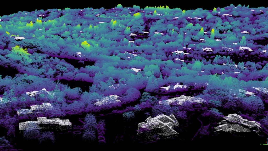
- NASA has published detailed three-dimensional topographic maps covering all of California, with resolution fine enough to resolve individual trees, to support statewide wildfire-risk assessment.
- The statewide map uses pixels one square meter in size, about 1.2 square yards, while most space-based lidar data resolve areas of 10 to 25 square meters per pixel.
- NASA's Wildfire, Ecosystem Resilience, and Risk Assessment Initiative team built the maps using airborne lidar and data collected by the U.S. Geological Survey's 3D Elevation Program.
- The initiative collaborated with the California Natural Resources Agency and the California Air Resources Board on the mapping work.
On Nov. 18, 2026, NASA released statewide three-dimensional topographic maps of California detailed enough to show individual trees for wildfire-risk assessment.
The map pixels measure one square meter, about 1.2 square yards. Most space-based lidar data cover far more ground per pixel, from 10 to 25 square meters. A NASA team called the Wildfire, Ecosystem Resilience, and Risk Assessment Initiative built the product at Ames Research Center using airborne lidar and elevation data from the U.S. Geological Survey’s 3D Elevation Program. Airborne lidar measures distance with a pulsed laser, and the state elevation data provides consistency across California.
NASA‘s initiative worked with the California Natural Resources Agency and the California Air Resources Board on the mapping. State agency partners are involved, so the resulting products can support California’s natural-resource and air-quality management goals. The team hopes to develop products for wildfire-risk assessment, protection of wildlife and ecosystems, and natural-resource management across California.
Lidar is short for light detection and ranging. A pulsed laser measures distances, so scientists can build three-dimensional maps of forests, cities and other worlds. Scientists already apply lidar broadly to map structure on Earth and elsewhere in the solar system.
EDGE, NASA’s Earth Dynamics Geodetic Explorer, will launch in 2030 to map ice, coastlines, plant life and terrain with detailed three-dimensional data. Helen Fricker, a glaciologist at UC San Diego, leads the mission, which carries a budget of up to $355 million for development, launch and maintenance across its full lifecycle. She works with NASA’s Goddard Space Flight Center and universities, including UCLA, to track shifts in Earth’s surface texture, such as melting ice and forest carbon removal.
The satellite will rely on five laser beams and laser altimetry to image ground elevation, forest vegetation and buildings from space. Timing laser pulses lets it see tree-canopy tops and lower branches through the canopy, revealing plant volume and density in one-meter vertical increments. Those profiles reveal the structure of undergrowth, shrubs and trees and can map ladder fuels that move fire from the ground into crowns.
Chris Hakkenberg, an associate researcher in UCLA’s Department of Geography, will co-lead forest biodiversity and habitat mapping. NASA approval of the planned wildfire component would let him direct the mission’s wildfire fuels work. According to Hakkenberg, the method resembles lidar used by autonomous vehicles and should provide gold-standard data for scientists and decision-makers.
Satellites currently provide far lower-resolution tree canopy data, and airborne lidar works best for roughly one-meter 3D structure mapping, though it depends on costly one-off flights over small areas. Hakkenberg says the results cannot be precisely replicated year to year since they depend on separate expensive flights. GEDI, NASA’s Global Ecosystem Dynamics Investigation, is the current leading spaceborne lidar, but it does not offer continuous coverage, one-meter vertical precision or near-global reach. EDGE aims to deliver near-continuous global vegetation data and could refresh maps several times each year.
A statistical model combining EDGE data with airborne lidar would create voxel maps of forests and terrain through unbroken three-dimensional swaths rather than separate profiles. The voxel map concept resembles a Minecraft-style three-dimensional grid, and it would support both habitat and fire-management applications. EDGE is part of NASA’s Earth Systems Explorers Program. The program seeks to advance understanding of surface topography, ecosystems and the atmosphere while supporting longer-range weather forecasting, and it frames the mission as part of a wider effort to use space observations for Earth-system understanding and prediction.
NASA’s Goddard Space Flight Center developed the Concurrent Artificially-intelligent Spectrometry Lidar System, or CASALS, backed by the Earth Science Technology Office. It closes gaps between isolated tracks from older spaceborne lidar systems by creating continuous ground swaths. CASALS steers laser light by wavelength rather than using moving mirrors, and it creates a continuous three-dimensional swath of the ground below. Cutting out motorized mirrors reduces size, weight and power needs and improves reliability in space.
The system uses a fast-pulsing tunable seed laser centered at 1,040 nanometers and cycles through 256 unique wavelengths using a transmission grating to aim each pulse at a different position. Diffraction causes different wavelengths to bend at different angles, so the grating separates the pulses across the flight path. CASALS operates at 80 percent quantum efficiency. The detector can catch faint return signals from dark surfaces or dense vegetation, and high quantum efficiency means the instrument wastes almost none of the returning light.
NASA flew an airborne CASALS prototype on its B200 King Air in November 2024. The prototype returned science-quality data on its first campaign. At roughly five kilometers altitude, the prototype reached 22-centimeter horizontal resolution, enough to distinguish individual tree branches and subtle elevation changes. “I’m very impressed with Guang Yang, Jeffrey Chen and all our engineers, and how well CASALS performed,” John Yorks said.
The team plans to fly CASALS again during the Airborne Surface, Cryosphere, Ecosystem, and Nearshore Topography campaign scheduled for summer 2027. The team will widen the instrument’s swath and add onboard data-processing software before building a space-ready prototype. If it succeeds, CASALS could become the first spaceborne lidar to produce unbroken three-dimensional swaths of forests and terrain instead of separate profiles. Continuous swath mapping would give a fuller view of Earth’s changing surface than legacy isolated tracks.




Join the discussion