
Key facts
- Two of the four Bandwagon-5 satellites serve Portugal's Atlantic Constellation, procured by CTI Aeroespacial and the Portuguese Air Force, bringing ICEYE-built satellites available to that constellation to four total.
- ICEYE’s Polish Armed Forces deployment achieved operational capability within 12 months of contract signing, and the company says this model is being replicated across Europe, the Middle East, and Asia.
- ICEYE’s SAR satellites launched on the Bandwagon-5 rideshare mission established communication and are undergoing commissioning as of October 20, 2026.
- Portugal’s first sovereign SAR satellite, launched earlier in 2026, is supporting national operations as part of ICEYE’s constellation.
ICEYE deployed four more synthetic aperture radar satellites into low-Earth orbit on Oct. 20, 2026, flying them from Cape Canaveral, Florida, on a SpaceX Bandwagon-5 rideshare mission.
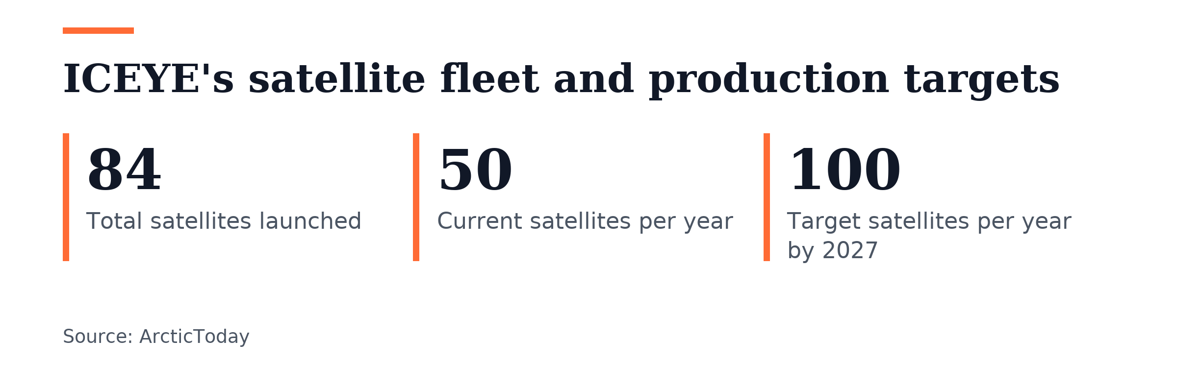
The Bandwagon-5 flight was ICEYE’s second launch in October 2026. Four more SAR spacecraft flew on SpaceX’s Transporter-18 mission on Oct. 1, 2026, and the Bandwagon-5 satellites have established communication and are undergoing commissioning. ICEYE has now launched 84 SAR satellites in total and plans to double annual output from 50 to 100 satellites by 2027.
Two of the four Bandwagon-5 spacecraft serve Portugal’s Atlantic Constellation, which CTI Aeroespacial and the Portuguese Air Force bought. The delivery raises the number of ICEYE-built satellites available to that constellation to four. A separate ICEYE spacecraft, Portugal’s first sovereign SAR satellite launched earlier in 2026, supports national operations within the constellation. ICEYE says its systems are sovereign and free from ITAR restrictions, and seven European governments have bought sovereign systems from it.
ICEYE and Arianespace signed a memorandum of understanding on Sept. 9, 2026, to study putting ICEYE radar Earth-observation satellites on Ariane 6 launch manifests for European governmental and institutional missions. Engineers from both companies will start compatibility studies and payload dispenser integration checks at Arianespace headquarters in Evry, France.
The teams will set launch windows and dual-launch options for Ariane 62 and Ariane 64 flights, placing smallsat SAR platforms into polar and sun-synchronous orbits from the Guiana Space Centre in Kourou, French Guiana. ICEYE’s X-band SAR sensors gather high-resolution radar imagery that sees through cloud cover, darkness and bad weather.
American agencies are buying ICEYE data too. ICEYE US won a place under NOAA’s Space-Based Environmental Monitoring IDIQ contract on Sept. 15, 2026, in the Active Sensors category. The National Reconnaissance Office chose ICEYE US for an operational radar augmentation program in August 2026 following a multi-year evaluation, and ICEYE US sells commercial SAR data through NASA’s satellite data acquisition program.
“NOAA sees the value commercial SAR provides during environmental emergencies, and this award creates a long-term pathway to build on that experience,” said Ann Stevens, Chief Executive Officer of ICEYE US. ICEYE calls its SAR fleet the world’s largest and most advanced. The company says its imagery works in any weather, day or night, with unmatched quality, latency and revisit times.
On Oct. 22, 2026, ICEYE announced a partnership with OroraTech to combine OroraTech thermal data with ICEYE SAR observations for full-lifecycle wildfire intelligence. The company says its SAR capabilities help customers assess building-level damage while wildfires burn. It says thermal intelligence adds visibility from initial ignition through impact, and that responders can issue disaster declarations within 24 hours instead of weeks.
ICEYE signed a deal with the California Governor’s Office of Emergency Services on Oct. 8, 2026, to put Flood Insights, Flood Rapid Impact and Wildfire Insights into state emergency management work. Cal OES started using the tools in February 2026, and they have since assisted with incidents across California and Washington. Cal OES also used ICEYE SAR data with FEMA during the 2025 Los Angeles fires. ICEYE says Flood Insights and Flood Rapid Impact supply detailed flood extent and depth data plus building-level impact intelligence, while Wildfire Insights gives structure-level damage assessments and near real-time views of active wildfires when smoke or darkness blocks other views.
ICEYE’s deployment for the Polish Armed Forces reached operational capability within 12 months after signing a contract. The company says it is replicating that approach in Europe, the Middle East and Asia.


Join the discussion