Key facts
- In early October 2026, CogniSAT-6 used onboard computer vision to examine a first image of the Pacific Ocean, spot a cruise ship, and work out its next revisit chance over the target area without ground interaction.
- Traditional Earth observation involves sending raw imagery down to ground stations for processing, human analysis and later tasking commands, producing delays of 30 minutes to a full day.
- Rijlaarsdam said autonomous scheduling could cut naval-operation delays, noting that standard observation requests may require anywhere from 30 minutes to a full day.
- Ubotica CEO Fintan Buckley described the result as a first-of-its-kind advance toward systems that let spacecraft rank targets, book images and work together across constellations.
On November 4, 2026, Ubotica Technologies showed that a spacecraft in low Earth orbit could use artificial intelligence to spot a vessel in the Pacific Ocean and plan its own follow-up image without ground commands.
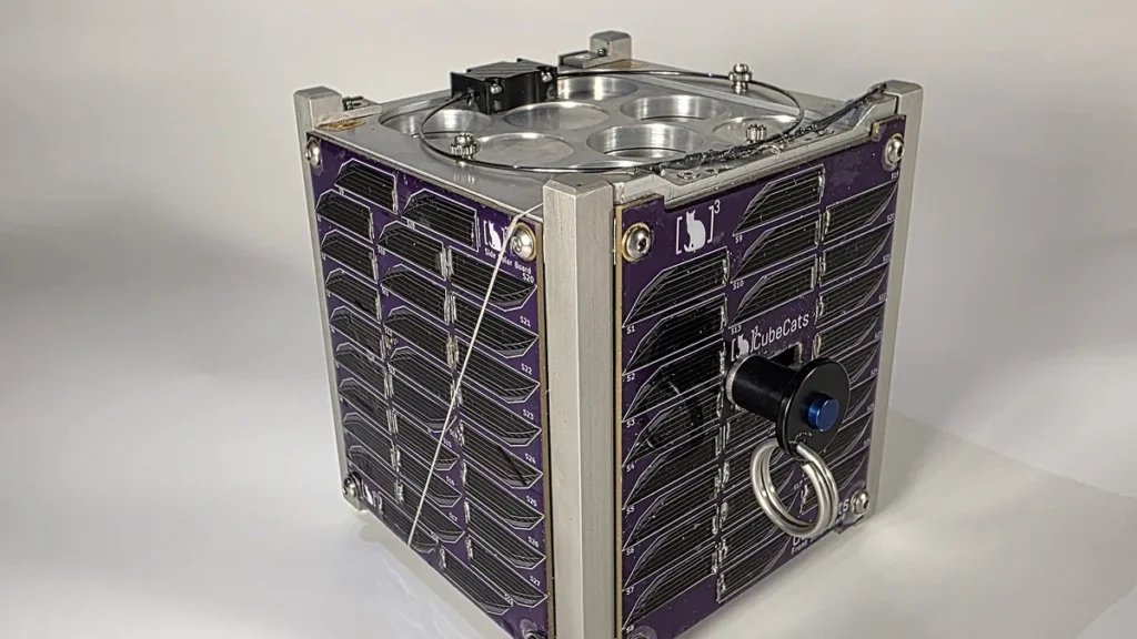
The demonstration used CogniSAT-6, an operational 6U CubeSat designed, built and operated by Open Cosmos. In early October 2026, CogniSAT-6 examined an initial image of the Pacific Ocean using onboard computer vision, identified a cruise ship, and calculated when it could next pass over the target area without communicating with the ground. Two days later, the satellite automatically took another picture of the same spot and confirmed the vessel had left. Launched in March 2024 aboard SpaceX’s Transporter-10 rideshare mission, which carries multiple payloads, CogniSAT-6 forms part of Open Cosmos’ OpenConstellation mutual infrastructure and carries Ubotica’s CogniSAT-XE2 platform for processing data on the satellite, building on earlier onboard AI validation flights.
Ubotica says conventional Earth observation involves sending raw imagery down to ground stations, where people process and analyze it before issuing later tasking commands, causing delays of 30 minutes to a full day. The company said its Live Maritime Intelligence platform brings together Orbital AI, satellite tasking and maritime data sources to spot new risks at sea and guide observation assets toward the places where they are most needed. The company said the platform seeks to create a changing view of maritime activity instead of depending on fixed imaging schedules, which helps governments and maritime agencies watch over and protect large ocean areas.
David Rijlaarsdam, Director of Space System Engineering at Ubotica, said the technology allows satellites to read their own imagery and pick their next step. “Autonomous Scheduling is about giving satellites the ability to interpret what they see and decide what to do next.” He said autonomous scheduling could shorten delays for naval operations, noting that routine observation requests can take anywhere from 30 minutes to a full day.
Fintan Buckley, Ubotica’s chief executive, described the result as a first-of-its-kind advance toward spacecraft that can rank targets, book images and cooperate across constellations. “This first-of-its-kind achievement marks a further step towards autonomous Earth observation systems.” The company called the November 4, 2026, demonstration a world first in commercial Earth observation and named the capability Autonomous Scheduling.
European governments are dealing with rising security pressures such as shadow fleets, vessels operating without identification signals, and risks to subsea communications cables and offshore energy infrastructure, Ubotica said. The company said cutting out ground station coordination could vastly speed up the gathering of critical maritime intelligence. David Rijlaarsdam said Autonomous Scheduling could eventually help track suspicious vessels, watch subsea infrastructure, and spot forest fires and volcanic activity.
Across groups of satellites, Ubotica plans to install autonomous scheduling software for automated tipping-and-cueing tasks supporting civil, naval and environmental monitoring. Tipping-and-cueing occurs when one satellite detects an object and directs others to image it next. The company framed Live Maritime Intelligence as serving security and resilience, with supporters suggesting orbital edge AI might turn into both a strategic asset and a commercial product.

In June 2026, Ubotica closed an $11 million funding round led by Act Venture Capital and Greencode Ventures, with Atlantic Bridge taking part as an existing investor. Ubotica said the money will accelerate deployment of its Live Maritime Intelligence service to give governments and maritime agencies earlier notice of suspicious activity at sea. The company said the latest funding aims to turn its technical record into a wider commercial offering.
Ubotica says its Orbital AI technology has completed hundreds of thousands of inferences while in orbit and supported more than 30 Earth observation models across missions, working with NASA’s Jet Propulsion Laboratory and the European Space Agency. The company began in Ireland, started by edge AI pioneers from Movidius and Intel, and says its technology has achieved a 100% mission success rate across many missions including CogniSAT-6.
On January 1, 2026, Ubotica said it worked with NASA’s Jet Propulsion Laboratory and Open Cosmos on the FAME initiative within NASA’s Advanced Information Systems Technology program, seeking to unite over 50 spacecraft into a coordinated autonomous network. Ubotica called FAME the most extensive test of autonomous satellite operations ever carried out. As part of FAME, Ubotica’s SPACE:AI platform will run aboard satellites to process data instantly.
The partnership among Ubotica, NASA JPL, and Open Cosmos reflects a wider move toward self-governing, linked satellite groups that can work together without continual human supervision and make decisions more quickly. The three organizations are working together on FAME to show AI-enabled spacecraft capable of making immediate decisions in orbit while depending less on ground control. “Ubotica’s breakthrough with NASA JPL and Open Cosmos is a powerful demonstration of what happens when scientific excellence meets entrepreneurial ambition,” said Ronan Furlong, Executive Director of DCU:Innovate Hub.
- 6U CubeSat: CogniSAT-6's size class
- Over 50 spacecraft: targeted by the FAME initiative
- More than 30: Earth observation models backed by Orbital AI
- Hundreds of thousands: inferences run in orbit
Ubotica said its Live Maritime Intelligence platform matters most for exclusive economic zones, which can stretch far beyond a country’s land area and prove hard to patrol regularly. The company said conventional satellite pictures frequently arrive too late when ships can turn off transponders, travel in shadow fleets, or avoid sanctions areas. Ubotica said its approach can transform satellite networks into a responsive surveillance layer, providing actionable intelligence within minutes instead of after extended processing on Earth.



Join the discussion