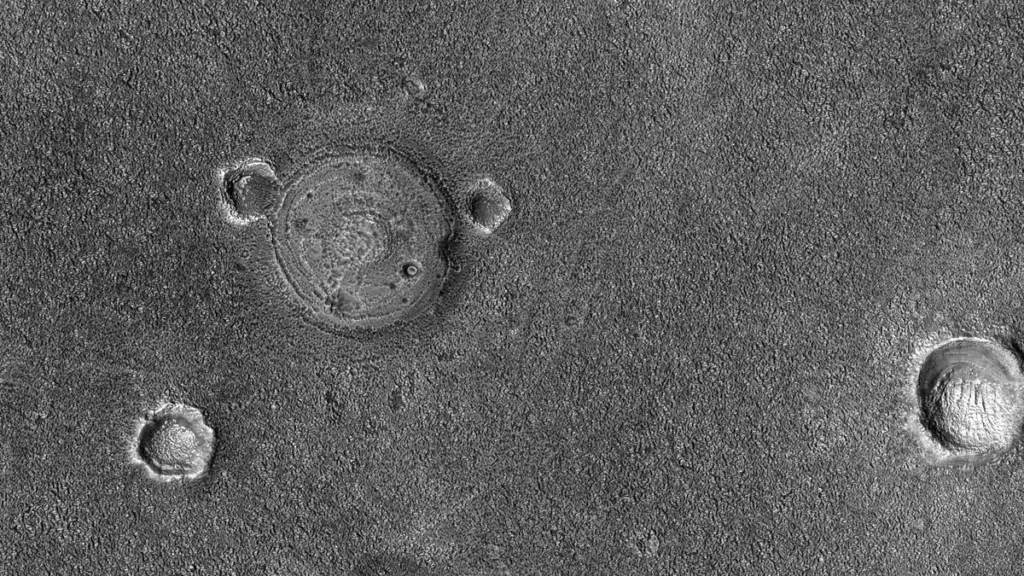
HiRISE captured high-resolution imagery of well-preserved polygons in Elysium Planitia and east of Apollinaris Patera on Monday, June 29, 2020. The observation was credited to NASA, JPL-Caltech, and the University of Arizona. It carries the identification number ESP_065269_1695. HiRISE took the imagery from an altitude of 264 km (163.68 mi).
The University of Arizona HiRISE page presents the entry as a HiPOD. Full observation details are available through the observation ID link. The page credits NASA, JPL-Caltech, and the University of Arizona. The black-and-white frame covers less than 5 km across, while the enhanced color image covers less than 1 km.
NASA/JPL-Caltech/University of Arizona describe the polygons as unusually well-preserved, which lets researchers examine their textures closely in Elysium Planitia and east of Apollinaris Patera. The team says the polygons often form because ice below the surface contracts and expands. Polygons on Mars frequently form through the expansion and contraction of subsurface ice, and HiRISE high-resolution images enable detailed examination of these textures.
NASA/JPL-Caltech/University of Arizona said the polygons are interesting features. “Polygons are interesting features on Mars, though sometimes only visible in high resolution images like those taken by HiRISE.”
The outlet also said HiRISE has sent back tens of thousands of pictures of Mars and that NASA is only scratching the surface in releasing them.
Autoevolution reported on July 30, 2022, that HiRISE captured the image in 2020, but NASA and the University of Arizona only recently made it public. The outlet said the image shows part of Elysium Planitia with many polygons that are generally only visible with the help of HiRISE. It called the polygons natural and said researchers believe they form due to subsurface ice contraction and expansion. Autoevolution added that such polygonal shapes are common on Mars, though the planet sometimes surprises with features found nowhere else.
The plain sits in Elysium Planitia, a broad region straddling the Martian equator centered at 3°00′N 154°42′E, south of the volcanic province of Elysium and near Apollinaris Mons. The plain is the setting for the new HiRISE polygon imagery. NASA’s InSight mission landed in western Elysium Planitia on November 26, 2018, after launching from Earth on May 5, 2018, at 4°30′N 135°54′E, about 600 km north of Gale Crater. The region also contains volcanic features, impact craters, and evidence of past ice floods and recent volcanic or explosive activity.
A 2005 Mars Express photo at 5°N, 150°E shows what may be ash-covered water ice estimated at 800 km by 900 km and 45 m deep. The ice is thought to be the remains of water floods from Cerberus Fossae fissures about two to 10 million years ago.




Join the discussion