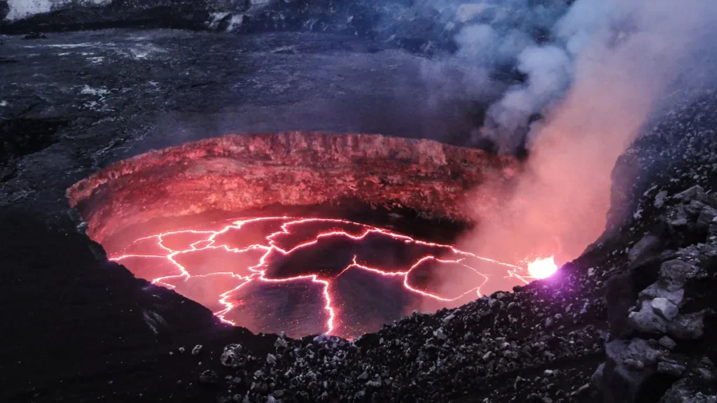
Researchers led by E. W. Dualeh used satellite synthetic aperture radar (SAR) backscatter at Puʻuʻōʻō in Kīlauea’s East Rift Zone on the Big Island of Hawaiʻi to test whether the method could trace lava flows, lava lake extent and crater depth changes, working with images captured from August 2010 to December 2013 and publishing the results in 2026.
The study appeared in 2026 in the Journal of Geophysical Research: Solid Earth as Interpreting Synthetic Aperture Radar Backscatter During Effusive Eruptions: Insights From Rift and Summit Activity at Kīlauea, Island of Hawai’i, by E. W. Dualeh et al., with DOI 10.1029/2026jb034913. Phys.org notes it republishes the story courtesy of Eos, hosted by the American Geophysical Union, and Eos lists the same journal article and DOI.
The team examined 167 ascending and 105 descending COSMO-SkyMed satellite images of lava flows and a lava lake at Puʻuʻōʻō’s crater between August 2010 and December 2013. The image set covered an active period of the decades-long Puʻuʻōʻō eruption and the team used it to test SAR backscatter against ground observations.
The researchers found that SAR measurements generally matched observed events during the eruptions studied from August 2010 to December 2013. Height changes at the crater floor, along with significant collapse and inflation, appeared in the radar shadow measurements. Lake perimeters and the positions of interior structures and vents emerged from backscatter readings of lava lakes.
Satellite-based synthetic aperture radar can monitor volcanic activity through thick plumes and clouds and at night. The technique responds to ground surface roughness and slope changes but sees limited use because signal changes can be hard to interpret in physical terms. Satellite resolution, noise levels and natural changes on the surface can also constrain its value.
Kīlauea on the Big Island of Hawaiʻi is an ideal place to test SAR backscatter because it hosts many monitoring stations with detailed geochemical, geological and geophysical data sets. Dualeh’s team proposes SAR backscatter as a monitoring source for effusive eruptions that satellites or instruments might overlook, and as a backup when direct ground viewing is not possible, not as a substitute for existing methods. Monitoring how a lava flow field grows can be hazardous and hard because gases escape, clouds block views, sites are difficult to reach, and local resources are scarce.
The slow-moving lava of an effusive volcanic eruption can transform a landscape.
A set of six new eruptive fissure vents opened in mid-September 2026 at Kīlauea’s summit along the western wall of Halemaʻumaʻu Crater. Once Episode 54 lava fountaining ended, the summit magma storage system re-pressurized during August, and that pressure increase produced the new vents. Scientists read pressure changes in the summit magma reservoir mainly from deformation readings gathered by summit instruments, such as tilt and GNSS (GPS) measurements of uplift and extension.
The Uēkahuna tiltmeter measured about 13 microradians of ground tilt downward toward the center of the crater on Aug. 25 during Episode 54, indicating a pressure decrease in the magma reservoir during fountaining. The pressure drop fully recovered by Sept. 7, when tilt returned to pre-fountaining level and the summit vents began to overflow, indicating the summit reservoir pressure was rebuilt.
Fountaining did not follow the overflows as in previous episodes; instead the summit storage system continued to further pressurize intermittently, leading to the new fissures opening Sept. 14-16. The vents sit 0.1 to 0.6 of a mile north of Halemaʻumaʻu’s main vent complex, where fountaining happens, and roughly 150 feet beneath the northern vent’s base level.
Monitoring found no notable seismicity or ground deformation near the new vents in September 2026, and an interferometric synthetic aperture radar image taken while the vents opened showed no meaningful surface movement around the vents or beyond them. With no seismicity or deformation detected, magma may have traveled through cracks or pathways already in place, or carved a new route without breaking much of the surrounding solid rock.
When magma intruded northeast of the eruptive vents in Halemaʻumaʻu from Sept. 30 to Oct. 1, lava stayed below ground while over 100 earthquakes and strong surface deformation appeared as fresh cracks formed on the caldera floor. One magnitude-3.1 earthquake was reported felt at 3:09 p.m. Oct. 12 located 7 miles south-southeast of Fern Forest at a depth of 3 miles, the only earthquake reported felt during the past week in the Hawaiian Islands.
Hawaiian Volcano Observatory geologists sampled lava from the new vents while they erupted in September 2026, collecting water-quenched samples by scooping molten lava into a bucket of water to rapidly cool it. The September lava’s texture and chemistry resemble material from the shallow magma chamber under Halemaʻumaʻu; the sample was mostly glass with few crystals and roughly 6.9 weight percent magnesium oxide, similar to Episode 54.
The new lava’s crystal-poor makeup and matching magnesium point to the shallow magma chamber beneath Halemaʻumaʻu, which supplies normal fountaining episodes, rather than new deep magma or an older buried lava lake. The combination of deformation and geochemical data shows the new fissure vents were the same magma source seen in previous fountaining episodes and likely formed because the highly pressurized magma system forced its way along the easiest path to the surface.
Kīlauea’s volcano alert level is Watch, and the volcano has erupted episodically since Dec. 23, 2024, within its summit caldera, with north and south vents in Halemaʻumaʻu intermittently erupting spatter and lava flows with strong overnight glow and flames. Sulfur dioxide emissions from Kīlauea are in the range of 1,000 to 5,000 tonnes per day, and the summit region remains at a high level of pressurization favorable for another fountaining episode or change in activity as of Oct. 16, 2026.
No unusual activity was noted along Kīlauea’s East Rift Zone or Southwest Rift Zone as of Oct. 16, 2026. Mauna Loa’s volcano alert level is Normal, Mauna Loa is not erupting, and the Hawaiian Volcano Observatory continues to closely monitor Kīlauea and Mauna Loa.

Join the discussion