Key facts
- Researchers from the University of Florence analyzed vegetation in 28 European capitals with 10-meter resolution using graph theory and found that a city's total green area can be misleading.
- One capital can have many parks yet leave them isolated, while another connects its green into a continuous functioning network.
- Giovanni D'Amico co-authored the University of Florence-led study that mapped vegetation across 28 European capitals at 10-meter resolution using graph theory.
- Stone pines (Pinus pinea) along Italy's Campania coast are being killed by invasive scale insect Toumeyella parvicornis, first recorded in the region in 2014.
Four 2026 studies and a Copernicus pilot show that Earth observation satellites now routinely monitor forests and green space across Europe. Researchers at the University of Florence, the GFZ Helmholtz Center in Potsdam and Kuva Space produced the work.
The University of Florence-led team mapped vegetation across 28 European capitals at 10-meter resolution using graph theory. Giovanni D’Amico said, “Satellites let us view urban green spaces as a connected system rather than isolated parks or trees”. One capital can have many parks yet leave them isolated, while another connects its green into a continuous functioning network.
D’Amico reconstructed the spread of invasive scale insect Toumeyella parvicornis among stone pines along Italy’s Campania coast between 2017 and 2025 using Sentinel-2 imagery and explainable artificial intelligence. The pest was first recorded in the region in 2014, and pest risk is largely driven by contagion. Field surveys cover limited areas and often detect damage only after it becomes visible on the ground, D’Amico said, while satellite maps help prioritize inspections.
The GFZ Helmholtz Center in Potsdam combined three decades of satellite-derived disturbance, biomass and tree-species maps with forest-age data. Simon Besnard said disturbances are increasingly affecting Europe’s older, carbon-rich forests, and the disturbed area of forest over 60 years old has nearly tripled since 2010. The GFZ-led study projects that if the pattern continues, carbon put at risk by natural disturbances could total around 20% of the carbon sink in Europe’s forests by 2040.
Researchers combined Landsat summer land-surface temperature measurements with a Europe-wide disturbance atlas and found that disturbed patches stay, 1.70 degrees Celsius warmer than nearby intact forest. More than 82% of that warming fades within a decade, and post-disturbance warming is strongest where canopy loss is most severe and in plantations. Forest management can influence the size and duration of the local heat footprint, Saverio Francini said.
Kuva Space tested hyperspectral data from Hyperfield-1 satellites alongside Sentinel-2 imagery under the Copernicus Contributing Missions program to improve land-cover classification. Between June 2025 and May 2026, Hyperfield-1 collected 98 hyperspectral images covering roughly 90,000 square kilometers across five test areas in Greece, Romania, France, the UK and Russia.
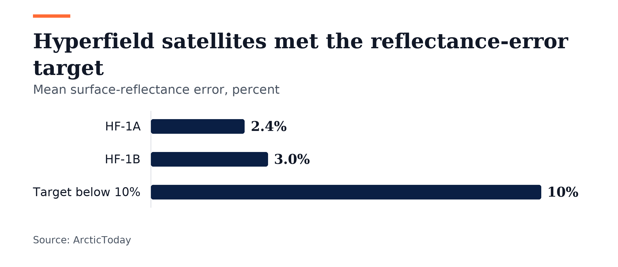
The combined hyperspectral and Sentinel-2 model outperformed both single-source models, and results were validated against hand-mapped land cover in three areas. Checked against RadCalNet, mean surface-reflectance error was 2.4% for HF-1A and 3.0% for HF-1B, well within the below-10% target. The pilot showed consistency between the two satellites, an important requirement for scaling up from individual images to a constellation-based service.
Kuva Space’s processing pipeline produces analytics outputs in under 10 minutes once data reaches the ground station, and when one input contained cloud, the combined model relied more heavily on the clearer source, so cloud did not leave a gap in that day’s mapping. The company is building six more Hyperfield satellites and plans 70-plus by end of the decade to improve accuracy and temporal coverage globally.
EU Member States were due to submit national restoration plans under the Nature Restoration Regulation by Sept. 1, 2026, and the regulation requires restoration measures on at least 20% of EU land and sea areas by 2030. The Copernicus Land Monitoring Service draws extensively on land-cover information to follow changes in vegetation, farmland, forests, built-up areas and other land types.
Join the discussion