Key facts
- The study describes Viscous Flow Features as key to understanding Mars's Late Amazonian climate history because planetary evolution may be recorded in their internal structure and dynamics.
- A new study in Earth and Planetary Science Letters reports 29 steep-fronted, pole-facing lobate deposits inside craters and pits larger than 2 km across in Mars's Alba Mons region.
- Glacial flow and climate model results indicate the deposits are leftover ice from a recent colder, high-obliquity period preserved on pole-facing crater slopes.
- The researchers interpret the Alba Mons deposits as debris-covered glaciers extending 1-3 km downslope and reaching thicknesses beyond 200 m at their termini.
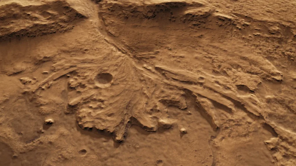
An international team published a study Nov. 20, 2026, in Earth and Planetary Science Letters describing 29 steep-fronted ice-rich deposits around Alba Mons in Mars’s northern hemisphere.
The deposits appear as steep-fronted, pole-facing lobate features inside craters and pits larger than 2 km across in the Alba Mons region. Of the 29 deposits, 24 occur inside craters and 5 inside pits, and all are larger than 2 km in diameter.
The researchers interpret the Alba Mons deposits as debris-covered glaciers extending 1-3 km downslope and reaching thicknesses beyond 200 m at their termini. Astrobiology Web states the deposits extend one to three kilometers downslope and can reach thicknesses exceeding 200 meters at their ends.
The steep terminal scarps rise tens to hundreds of meters and reach slopes of up to 42 degrees, truncating surface flow features. The researchers propose the scarps form because ice sublimates (turns directly from solid to vapor) at the glacier edges. Astrobiology Web says the scarps resemble steep termini of debris-covered or rock glaciers on Earth, a morphology not previously described for Martian debris-covered glaciers. This steep angle is the defining trait of the deposits and is presented as part of a morphology not previously seen in Martian debris-covered glaciers.
Slopes reach as far as 3 kilometers and end in cliffs up to 209 meters high. Yahoo Tech describes the downward slopes extending as far as 3 kilometers in some cases and ending abruptly in sheer cliffs as high as 209 meters.
The steep fronts carry two superposed textural units that the researchers say represent separate glacier parts rather than internal layers. Researchers describe a lower unit of rougher, steeper debris that looks moraine-like, above which sits a smoother unit matching the ice-rich glacier body, with debris gathered at the front. The lower debris unit probably came from degraded crater headwalls, moved with the glacier, and piled up at the front while ice vanished by sublimation.
A debris-covered glacier in northern Iceland has similar frontal shapes, backing up the two-unit interpretation of the Martian deposits. Astrobiology Web reports that the terrestrial comparison reveals comparable front morphologies and supports the reading of the paired units on Mars.
The glacier ice deposits are currently covered by rocks, dust, and other debris, and this covering protects the ice against the atmosphere. The debris layer explains how ice can persist under present Martian conditions and is directly relevant to accessing the ice for future missions.
The study calls these landforms Viscous Flow Features, or VFFs, and says they are key to understanding Mars’s Late Amazonian climate history because planetary evolution may be recorded in their internal structure and dynamics. Astrobiology Web frames these ice-rich landforms as crucial to decoding Mars’s climate evolution because the planet’s history may be stored in the deposits’ internal structure and flow behavior. Yahoo Tech repeats the researchers’ assertion that VFFs are central to understanding the Late Amazonian period.
Glacial flow and climate model results indicate the deposits are leftover ice from a recent colder, high-obliquity period preserved on pole-facing crater slopes. The researchers say the current geometry is out of balance, with ice deficits in distant zones and excess ice in source areas, and that ice flow plus marginal sublimation created the steep fronts.
Team members say the deposits might reveal when this part of Mars last held ice and how climate changed, because the planet’s tilt has shifted over time. Mars’s tilt has changed over history, shifting its temperature patterns and the movement of water and ice. The article uses this climatic history to explain why the deposits may date from a recent colder period and why they help track when ice last covered the region.
Alba Mons lies in the northern hemisphere of Mars. Mars is almost 600 times farther away than the Moon.
Mars’s atmosphere is now too thin and cold to sustain liquid water, though surface ice remains abundant near the poles and subsurface ice is believed to lie beneath the crust. Yahoo Tech provides background on Mars’s ice and water history before describing the Alba Mons discoveries around the northern-hemisphere volcano.
An international team studied images from NASA’s Mars Reconnaissance Orbiter and ESA’s ExoMars Trace Gas Orbiter to identify the landforms. Yahoo Tech says the geological features were picked out using imagery from those two orbiters, forming the observational basis for the study.
The researchers examined 738 craters, built 3D maps from paired satellite images, ran computer models, and compared the Martian shapes to similar Icelandic features. Yahoo Tech explains that pairs of satellite images were used to build 3D maps and that computer modeling helped interpret how the glaciers formed and how the geology should be read.
Some cliffs show rocks that fell from crater rims, traveled down slopes, and gathered at the bottom. Yahoo Tech notes this rockfall evidence is relevant to future attempts to access water reserves because it shows how debris is distributed over the ice.
The deposits matter for future attempts to access Martian water reserves because they indicate where ice is located and how well it is covered, and the study is a significant help for that goal. The article links the debris-covered glaciers to human exploration, saying knowing ice location and cover depth matters for astronauts.
Future work may include sharper imagery of Alba Mons, a hunt for similar deposits elsewhere on Mars, and another trip to Iceland. Yahoo Tech lists next steps for studying the craters, including more detailed imagery, a search for similar formations across the planet, and examining Earth-based equivalents in Iceland.
Local topography and debris-ice interactions control whether these deposits survive, how they evolve and what shape they take on Mars. The steep-fronted morphology has not been previously described for Martian debris-covered glaciers, though it resembles steep termini of debris-covered or rock glaciers on Earth. The researchers position the Alba Mons deposits as a new glacial landform for Mars while drawing on terrestrial analogs to interpret their shape. This is the study’s concluding emphasis on the controls that determine how Martian ice-rich landforms survive and change over time.


Join the discussion