Key facts
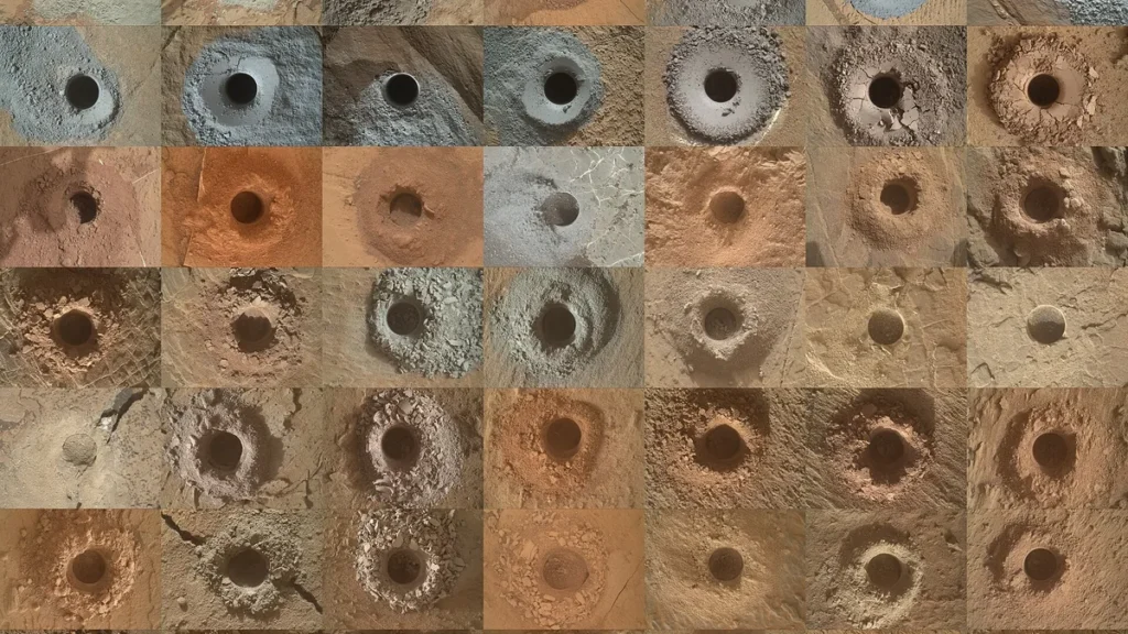
- NASA published a collage showing all 49 drill holes made by Curiosity on Mars as of November 2026.
- Every drill hole pictured measures 0.63 inches (16 millimeters) across.
- Curiosity drilled its 49th hole at a rock target called Nazca during Sols 5050 through 5055, with Earth-side planning on October 23, 2026.
- Schwenzer wrote that the team chose Nazca because the rock holds abundant disc-shaped features.
NASA published a collage on Nov. 16, 2026 showing all 49 drill holes made by the Curiosity rover on Mars, with each hole measuring 0.63 inches (16 millimeters) across and captured by the MAHLI camera on the end of the rover’s robotic arm.
Every hole pictured represents a sample that the drill pulverized and dropped into instruments inside the rover’s belly for composition analysis. MAHLI was built by Malin Space Science Systems in San Diego.
The 49th hole was drilled at a rock target called Nazca during Sols 5050 through 5055, after Earth-side planning on Oct. 23, 2026. Planetary mineralogist Susanne P. Schwenzer of The Open University wrote in a NASA mission blog that the team chose Nazca because it holds abundant disc-shaped features that scientists read as potential crystals. Comparing them with comparable crystals on Earth helps indicate the environmental conditions under which the rock formed.
Before drilling, Curiosity passed a stability test confirming all wheels stood on solid ground and a preload test checking rock stability and arm forces. Only after both safety checks succeeded did the drill campaign proceed. The rover studied Nazca with APXS, MAHLI and ChemCam before drilling, then deposited the powdered sample into CheMin after the hole was finished.
Results from the Nazca sample held in CheMin were still traveling from Mars to Earth as of the Nov. 10, 2026 report, so the analysis has not yet reached Earth. Schwenzer said the team calls the discs potential crystals only, and Nazca remains a test of an interpretation rather than a confirmed discovery. The CheMin results from the Nazca sample were expected over the weekend following the November 10 report.
ChemCam measured the tailings around the Nazca hole using passive spectral data and active LIBS, then took another LIBS reading down the drill-hole wall. The instrument also fired its laser at a dark pebble named Palpala and identified another pebble called Puna during Friday planning, while Llama received a LIBS depth profile and Pacaya was measured for disc-shaped forms. ChemCam planned long-distance RMI images of Mishe Mokwa and Cordillera, two buttes whose sedimentary structures and textures have interested the team for a long time.
Curiosity landed on Mars on Aug. 5, 2012, and has operated for 14 years. Billions of years ago, lakes and streams spread across the lower foothills of Mount Sharp, a 3-mile-tall (5-kilometer-tall) mountain the rover has climbed since 2014. The rover found chemical traces from that wetter period, including carbon-based molecules seen as precursors to RNA and DNA.
Scientists cannot determine whether those organic molecules came from biologic or geologic processes, and both explanations remain possible. The discovery confirmed once again that ancient Mars contained the chemical ingredients needed to support life.
Curiosity recently climbed to 0.6 miles (1 kilometer) of elevation on Mount Sharp, the highest elevation ever reached on Mars. The rover is in its second year of a fifth extended mission and will drive across sulfate-rich and carbonate-rich layers for much of the coming year.
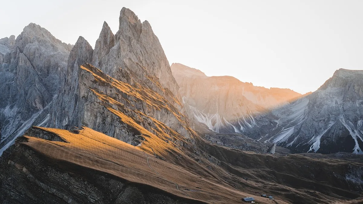
Curiosity entered a Martian valley nicknamed Valle Grande, where polygonal fractures measuring about 1.5 to 3 inches (4 to 8 centimeters) across form a honeycomb field. The patterns wrap around a nearby 20-foot-tall (6-meter) butte nicknamed Miraflores, capped by a thick layer of sand. Curiosity had previously seen small clusters of similar polygonal shapes but never anything approaching the scale of the field now visible in Valle Grande.
The full extent of the polygon formations appears in a 360-degree panorama captured on June 19 and 20, during sols 4,930 and 4,931 of the mission. Some polygonal formations previously examined by Curiosity clearly began as cracks in drying mud, but several different processes can produce this honeycomb appearance, including repeated warming and cooling fracturing the ground and compression forcing water out of buried sediment.
Mission project scientist Ashwin Vasavada of NASA’s Jet Propulsion Laboratory said the sea of polygons took the team’s breath away, and that they measured the shapes and chemistry carefully and are hopeful there are clues in the data as to how the features formed. Scientists are studying the Valle Grande polygon formations to determine which process, or combination of processes, shaped the landscape.
Curiosity’s journey has brought sulfur crystals, reflective meteorites, and an assortment of other unusual geologic features into view. Water, useful chemistry, and nutrients capable of supporting microbial life once existed on ancient Mars, and Curiosity’s evidence of this has transformed scientists’ understanding of the planet.
A Mastcam panorama of distant wind-carved Martian cliffs called yardangs was captured at 8:30 a.m. local Mars time on Aug. 11, the 4,982nd sol of the mission, comprises six stitched images and was processed without white balancing to preserve the early morning appearance. The yardang layer stretches across roughly 10 miles (16 kilometers) of northwestern Mount Sharp.
Ashwin Vasavada said the yardang layer looks out of place, has the wrong color, tilts at an odd angle, and almost appears plastered on; one idea is it may be ash deposited by ancient volcanic eruptions. Mount Sharp is made up of layers, each recording a distinct period of Mars’ history; eventually the water dried up and left salty minerals behind, and after new material stopped settling, some of it may have been stripped away by wind, giving rise to the yardangs.
Curiosity’s fifth extended mission, now in its second year, started with exploration of spiderweb-like boxwork ridges. Scientists hope to reach the yardangs’ base in 2027, when Curiosity can use its robotic arm to collect data available nowhere else.
JPL built Curiosity and leads the mission for NASA’s Science Mission Directorate as part of the Mars Exploration Program, while Caltech manages JPL in Pasadena, California. The rover returned to an area where it had earlier found disc-shaped inclusions in the rocks, which scientists interpret as potential crystals.




Join the discussion